
India-Pakistan Relations: A Military Geography Perspective
Explore the strategic landscape of India-Pakistan relations, covering border geography, nuclear doctrines, military history, and future outlook.
MILITARY GEOGRAPHY SYLLABUS
INDIA–PAKISTAN RELATIONS
A Military Geography Perspective
Geopolitics · Border Disputes · Nuclear Deterrence · Strategic Alliances
Prepared for Military Geography Curriculum | May 2026
CONTENTS
01
Historical Background & Partition (1947)
02
Geopolitical Overview & Strategic Location
03
Line of Control & Border Geography
04
Major Wars & Military Conflicts
05
Nuclear Dimension
06
Proxy Warfare & Terrorism
07
Recent Escalations (2016–2025)
08
Strategic Alliances & Future Outlook
Prepared for Military Geography Curriculum | May 2026
01
HISTORICAL BACKGROUND
The Partition of 1947 & Its Military Legacy
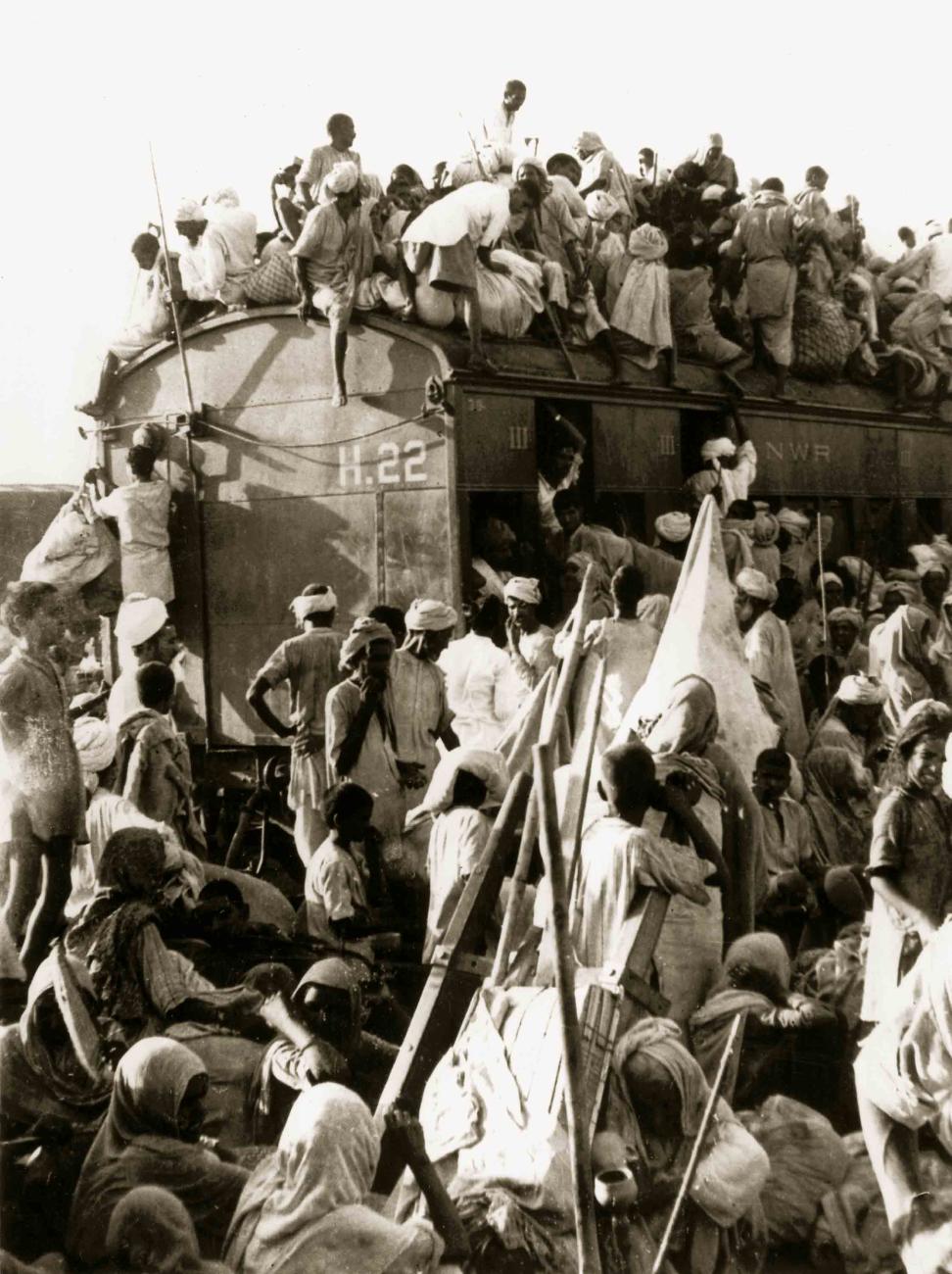
British India partitioned on 14–15 August 1947 into India & Pakistan
Mass migration of 10–20 million people; 200,000–2,000,000 deaths
Princely state of Jammu & Kashmir — accession dispute triggers First Kashmir War (1947–48)
UN Resolution 47 (1948) calls for plebiscite — never held
Radcliffe Line drawn in 5 weeks — arbitrary borders cut through communities, rivers & strategic terrain
Seeds of permanent military rivalry planted from Day 1
MILITARY GEOGRAPHY SYLLABUS
02
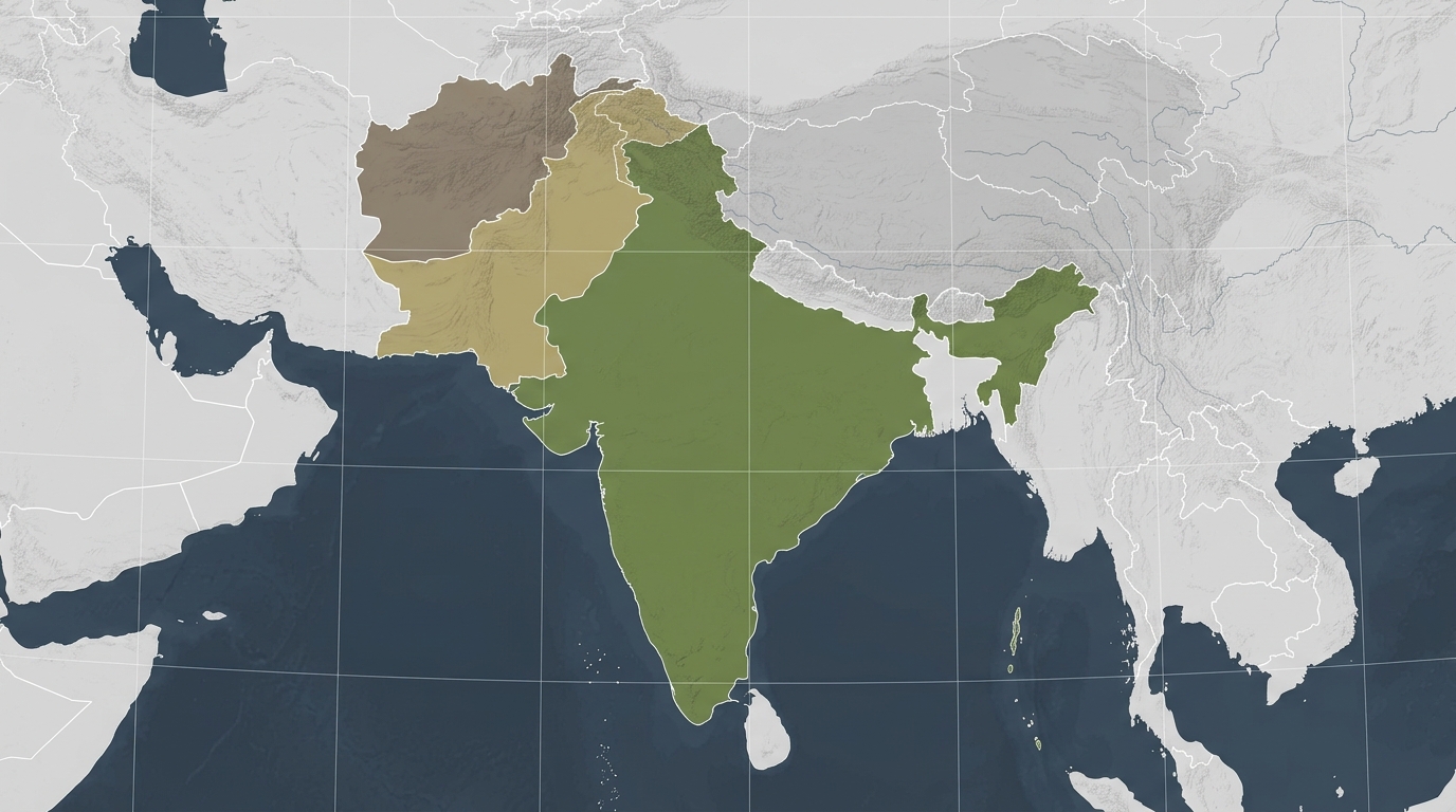
GEOPOLITICAL OVERVIEW & STRATEGIC LOCATION
LAND BORDERS
India-Pakistan
~3,323 km
LoC
~740 km
STRATEGIC CHOKEPOINTS
Khyber Pass, Bolan Pass, Strait of Hormuz access
RIVAL ALLIANCES
India
US/Russia quad
Pakistan
China/Saudi Arabia
POPULATION
India
1.44B
Pakistan
230M
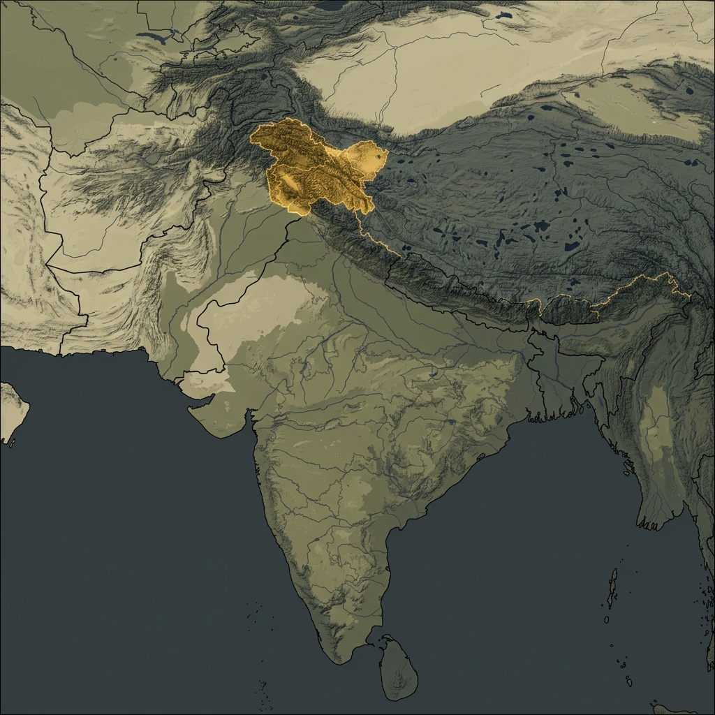
03
LINE OF CONTROL & BORDER GEOGRAPHY
THE LINE OF CONTROL (LoC)
Length: ~740 km | Established: Simla Agreement, 1972
Divides Indian J&K/Ladakh from Pakistan's Azad Kashmir
Heavily fortified — fencing, bunkers, observation posts
~500,000 Indian troops deployed along LoC
SIACHEN GLACIER
World's highest battlefield — 19,000–22,000 ft elevation
India controls Saltoro Ridge since Operation Meghdoot (1984)
Actual Ground Position Line (AGPL) — 110 km frontline
Cost: ~$1 million/day per side
RADCLIFFE LINE (International Border)
Runs through Punjab plains to Rajasthan/Sindh
Sir Cyril Radcliffe drew it in just 5 weeks (1947)
MILITARY GEOGRAPHY SYLLABUS
04
MAJOR WARS & MILITARY CONFLICTS
1947–48
FIRST KASHMIR WAR
• Pakistan-backed tribals invade Kashmir • India airlifts troops • LoC established • UN intervention
1965
OPERATION GIBRALTAR
• Pakistan infiltrates Kashmir • Full-scale war • Battle of Asal Uttar • USSR/US mediated Tashkent Agreement
1971
INDO-PAK WAR
• Bangladesh Liberation War • India's decisive victory • 93,000 Pakistani POWs • Simla Agreement 1972
1999
KARGIL WAR
• Pakistan occupies Kargil heights • India's Operation Vijay • First war between nuclear-armed states • Pakistan forced to withdraw
2019
BALAKOT STRIKES
• Post-Pulwama • India's first air strikes inside Pakistan since 1971 • New escalation threshold set
INDIA-PAKISTAN RELATIONS | MILITARY GEOGRAPHY PRESENTATION
05
THE NUCLEAR DIMENSION
South Asia's Nuclear Standoff
🇮🇳 INDIA
Nuclear tests:
1974 (Pokhran-I) & 1998 (Pokhran-II)
Estimated warheads:
~170 (2024)
Doctrine:
No First Use (NFU)
Delivery:
Agni missile series (range up to 5,000+ km), Prithvi, Brahmos, nuclear submarines (INS Arihant)
Posture:
Minimum credible deterrence
🇵🇰 PAKISTAN
Nuclear tests:
1998 (Chagai-I & II) — direct response to India
Estimated warheads:
~170 (2024)
Doctrine:
First Use (no NFU) — compensates for conventional inferiority
Delivery:
Shaheen missile series, Ghauri, Nasr (tactical nuclear weapon)
Posture:
Full spectrum deterrence
KEY STRATEGIC IMPLICATION
Pakistan's First Use doctrine and Nasr tactical nuclear weapon (TNW) are designed to deter India's Cold Start conventional strategy — creating the most dangerous nuclear flashpoint in the world.
06
PROXY WARFARE & TERRORISM
Pakistan's Sub-Conventional Strategy
KEY MILITANT GROUPS
Lashkar-e-Taiba (LeT) — 2008 Mumbai attacks
Jaish-e-Mohammed (JeM) — 2001 Parliament attack, 2019 Pulwama
Hizbul Mujahideen (HuM) — Kashmir-focused
The Resistance Front (TRF) — 2025 Pahalgam attack (26 killed)
All proscribed by UN Security Council
STRATEGIC RATIONALE
Asymmetric counter to India's conventional superiority
"Bleed India with a thousand cuts" doctrine
Deniability shields Pakistan from direct retaliation
ISI linkages to multiple groups documented
Exploits Kashmir's popular grievances
Cost-effective vs. conventional arms race
INDIA'S COUNTER-STRATEGY
Intelligence-based targeted operations
Surgical strikes (2016 Uri response)
FATF pressure — Pakistan grey-listed 2018–2022
Diplomatic isolation efforts
Operation Sindoor (May 2025) — direct strikes on terror infrastructure in Pakistan Punjab
07
RECENT ESCALATIONS: 2016–2025
New Thresholds in India-Pakistan Conflict
2016 URI ATTACK
Jaish suicide attack on army base; 19 soldiers killed. India conducts surgical strikes across LoC. New retaliatory doctrine established.
2019 PULWAMA–BALAKOT
JeM suicide bombing kills 40 CRPF personnel. India launches air strikes on Balakot, Pakistan (first since 1971). Pakistan retaliates; aerial dogfight; IAF Wing Cdr Abhinandan captured & released.
2025 PAHALGAM ATTACK
TRF kills 26 tourists in Baisaran Valley, Kashmir (22 Apr 2025). India suspends Indus Waters Treaty, expels diplomats.
2025 OPERATION SINDOOR
India strikes 9 terror sites in Pakistan including Muridke & Bahawalpur (7 May 2025). Pakistan responds with 300–400 drones, heavy shelling of Poonch (worst in 50 years). CEASEFIRE: 10 May 2025. South Asia's first multi-domain warfare.
KEY LESSON:
India has progressively lowered its threshold for cross-border military action while Pakistan has expanded its drone and missile response capability.
MILITARY BALANCE & STRATEGIC ASYMMETRIES
Despite India's decisive conventional superiority, Pakistan's nuclear First Use posture and sub-conventional strategy create strategic parity — the 'equalizer effect'.
~$83 billion (2024)
~$10 billion (2024)
1,455,550
654,000
1,237,117
560,000
4,614
2,627
600+
400+
150+
50+
~170
~170
No First Use
First Use
Up to 5,500 km (Agni-V)
Up to 2,750 km (Shaheen-III)
No
Yes (China-Pakistan Economic Corridor)
08
STRATEGIC ALLIANCES & REGIONAL DYNAMICS
INDIA'S ALLIANCES
PAKISTAN'S ALLIANCES
CHINA FACTOR
China's support to Pakistan forces Indian military planners to prepare for a <strong style="color: #D6A942; font-weight: 600;">TWO-FRONT WAR</strong> scenario — the single greatest strategic challenge for India.
USA
Strategic partnership; Quad member; BECA, LEMOA, COMCASA agreements; F-414 engine deal
Russia
Historic arms supplier; S-400 system; BrahMos co-development
Quad
India, USA, Japan, Australia — maritime security framework
France
Rafale jets; nuclear-capable delivery platform
Israel
Drones, missile defence, intelligence sharing
Iran
Chabahar Port — strategic bypass of Pakistan
China
"Iron brother" — CPEC ($62B infrastructure); JF-17 Thunder jets; HQ-9 SAM systems; diplomatic cover in UNSC
Saudi Arabia / UAE
Financial lifeline; oil subsidies; strategic Islamic solidarity
Turkey
Bayraktar TB2 drones (used in 2025 conflict); naval cooperation
USA (historical)
Cold War ally; post-2001 GWOT partner; relation now strained
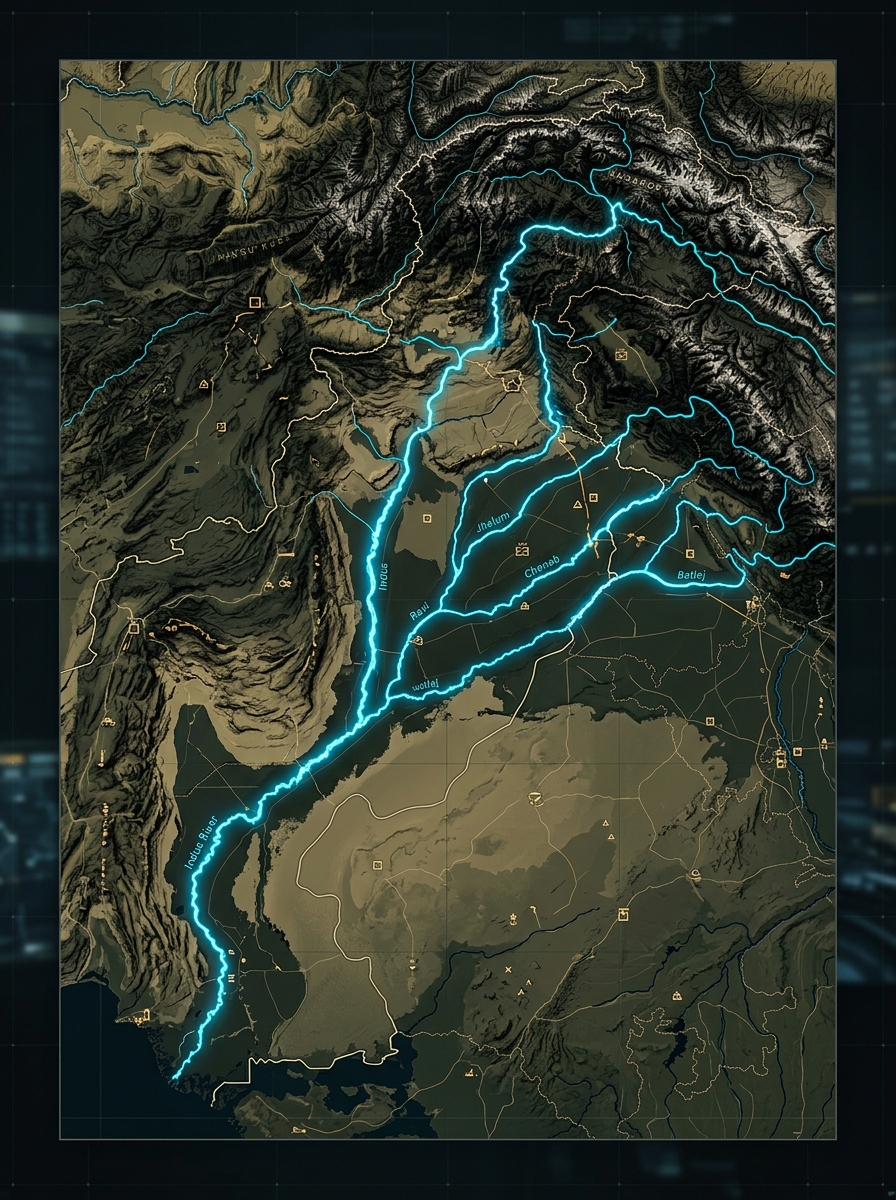
WATER SECURITY
INDUS WATERS TREATY & WATER WARFARE
THE INDUS WATERS TREATY (1960)
Signed by India & Pakistan; brokered by World Bank
Survived 3 wars and 60+ years of hostility
India controls: Ravi, Beas, Sutlej (Eastern rivers)
Pakistan controls: Indus, Jhelum, Chenab (Western rivers — 80% of flow)
Provides 65% of Pakistan's irrigation water
2025 SUSPENSION
India suspended the treaty on 23 April 2025 — following Pahalgam attack
First suspension in treaty's 65-year history
Pakistan declared any water diversion "an ACT OF WAR"
Treaty suspension as coercive diplomacy — new strategic tool
MILITARY GEOGRAPHY SIGNIFICANCE
Water is Pakistan's existential vulnerability
River systems follow strategic corridors used in military operations
Chenab, Jhelum valleys are natural invasion routes
MILITARY GEOGRAPHY SYLLABUS
FUTURE OUTLOOK & STRATEGIC LESSONS
Key Takeaways for Military Geography
GEOGRAPHY IS DESTINY
The Kashmir terrain, Himalayan barrier, and Indus water system make India-Pakistan rivalry structurally enduring. Geography creates both the flashpoints and the constraints.
NUCLEAR SHADOW
All conventional military planning must account for Pakistan's First Use doctrine. Nuclear deterrence limits India's conventional advantages and raises the cost of escalation.
MULTI-DOMAIN WARFARE
The 2025 conflict demonstrated that future India-Pakistan wars will involve drones, missiles, cyber, and information operations simultaneously — not just ground/air battles.
CONTINUED LOW-INTENSITY CONFLICT
Cross-border terrorism, LoC skirmishes, drone incursions remain the dominant mode
CALIBRATED COERCION
Periodic precision strikes like Op Sindoor become the new normal; each side recalibrates thresholds
NUCLEAR RISK
Miscalculation during crisis escalation remains the gravest existential threat to South Asia
MILITARY GEOGRAPHY SYLLABUS | INDIA–PAKISTAN RELATIONS
Prepared May 2026
- geopolitics
- india
- pakistan
- military-geography
- kashmir
- nuclear-doctrine
- strategic-studies