Made byBobr AI

Interactive Geospatial Intelligence: Querying the Earth

Explore how modern geospatial systems use AI and ML to turn planet-scale satellite imagery into real-time, searchable data for economic and activity tracking.

#geospatial-intelligence#satellite-imagery#machine-learning#sar-radar#data-engineering#ai#remote-sensing
Watch
Pitch

Interactive
Geospatial Intelligence

How modern systems turn imagery into real-time answers

SECTION 1 — HOOK
Made byBobr AI

The Real Problem

Too much imagery

Too little time

Manual analysis doesn't scale

SECTION 1 — HOOK
Made byBobr AI

What's Changed Recently

Before
More data.
Same slow analysis.
Now
Interactive systems.
Real-time answers.
From ANALYSIS INTERACTION
SECTION 1 — HOOK
Made byBobr AI

The New Paradigm

You don't analyse imagery anymore.

You query it.

DRAW
SEARCH
REFINE
SECTION 2 — THE CORE IDEA
Made byBobr AI

What Enables This

3 building blocks

1

Tiling

Break imagery into manageable chunks at scale

2

Feature Extraction

Teach machines to understand what they see

3

Similarity Search

Find matching patterns at speed

SECTION 2 — THE CORE IDEA
Made byBobr AI
The Mental Model

Google for pixels.

Drawing / Example
System
Similar pixels everywhere
SECTION 2 — THE CORE IDEA
Made byBobr AI
CAPABILITY SPOTLIGHT #1

Real-Time Feature Extraction

Turn imagery → structured data instantly

Extract buildings, roads, features automatically

Works at planetary scale

Structured output from raw pixels

Example

AI-powered semantic 3D mapping of the entire Earth

SECTION 3 — PLAYER SPOTLIGHTS
Made byBobr AI
CAPABILITY SPOTLIGHT #2

All-Weather, Always-On Sensing

See what others can't

SAR = Synthetic Aperture Radar (not optical)
Penetrates clouds, works at night
Persistent coverage regardless of conditions
Example

World's largest SAR satellite constellation

SECTION 3 — PLAYER SPOTLIGHTS
Made byBobr AI
CAPABILITY SPOTLIGHT #3

Large-Scale Geospatial ML Platforms

Run models across the planet

Execute ML pipelines across massive global datasets
Time-series analysis across months/years
Global coverage, cloud-native
Example

Planetary-scale geospatial analytics platform

SECTION 3 — PLAYER SPOTLIGHTS
Made byBobr AI
CAPABILITY SPOTLIGHT #4

Economic & Activity Detection
from Space

Infer behaviour, not just objects

Detect cars in parking lots → measure retail activity
Count ships in ports → track trade flows
Read economic patterns from orbit
EXAMPLE
Geospatial analytics for economic intelligence
SECTION 3 — PLAYER SPOTLIGHTS
Made byBobr AI
CAPABILITY SPOTLIGHT 5 — THE UPGRADE

Multi-Sensor Intelligence

Fusion of different data types

  • Radio frequency RF signals from space
  • Combined with optical imagery
  • Detect what you cannot see, only hear
  • Multi-layer intelligence fusion
Example

RF signal geolocation plus imagery fusion

SECTION 3 PLAYER SPOTLIGHTS
Made byBobr AI

Shared Architecture Pattern

Every major geospatial intelligence platform does this:

1

INGEST

Massive data intake

2

TILE

Break into manageable chunks

3

EXTRACT

Run feature models

4

STORE

Fast-access vector storage

5

QUERY

Real-time retrieval

This is a data engineering problem as much as an AI problem.

SECTION 4 — WHAT THEY HAVE IN COMMON
Made byBobr AI

The Real Innovation

It's not the models.

PRECOMPUTATION

Do the heavy work ahead of time

SMART STORAGE

Structure data for instant retrieval

FAST RETRIEVAL

Sub-second query at global scale

AI is just one layer. The real innovation is the system.

SECTION 4 — WHAT THEY HAVE IN COMMON
Made byBobr AI

Minimal System You Could Build

A modular, composable pipeline — starting today

node_01
[STEP_01]

STORE

$ execute

> Cloud-Optimized
GeoTIFF (COG) on S3

node_02
[STEP_02]

TILE

$ execute

> Slice into
XYZ tiles

node_03
[STEP_03]

EXTRACT

$ execute

> Run model ->
generate embeddings

node_04
[STEP_04]

INDEX

$ execute

> Store vectors
in FAISS

node_05
[STEP_05]

QUERY

$ execute

> Expose via
REST API

Modular. Composable. Buildable now.
SECTION 5 — HOW YOU WOULD BUILD THIS
Made byBobr AI

“You don't need satellites
to innovate here.”

Use open imagery
Build small prototypes
Focus on interaction

The opportunity is in UX + systems, not just data.

SECTION 5 — FINAL THOUGHT
Made byBobr AI
Bobr AI

DESIGNER-MADE
PRESENTATION,
GENERATED FROM
YOUR PROMPT

Create your own professional slide deck with real images, data charts, and unique design in under a minute.

Generate For Free

Interactive Geospatial Intelligence: Querying the Earth

Explore how modern geospatial systems use AI and ML to turn planet-scale satellite imagery into real-time, searchable data for economic and activity tracking.

Interactive<br>Geospatial Intelligence

How modern systems turn imagery into real-time answers

SECTION 1 — HOOK

The Real Problem

Too much imagery

Too little time

Manual analysis doesn't scale

SECTION 1 — HOOK

What's Changed Recently

Before

More data.<br>Same slow analysis.

Now

Interactive systems.<br>Real-time answers.

ANALYSIS

INTERACTION

SECTION 1 — HOOK

The New Paradigm

You don't analyse imagery anymore.

You query it.

DRAW

SEARCH

REFINE

SECTION 2 — THE CORE IDEA

What Enables This

3 building blocks

Tiling

Break imagery into manageable chunks at scale

Feature Extraction

Teach machines to understand what they see

Similarity Search

Find matching patterns at speed

SECTION 2 — THE CORE IDEA

The Mental Model

Google for pixels.

Drawing / Example

System

Similar pixels everywhere

SECTION 2 — THE CORE IDEA

CAPABILITY SPOTLIGHT #1

Real-Time Feature Extraction

Turn imagery → structured data instantly

Extract buildings, roads, features automatically

Works at planetary scale

Structured output from raw pixels

Example

AI-powered semantic 3D mapping of the entire Earth

SECTION 3 — PLAYER SPOTLIGHTS

CAPABILITY SPOTLIGHT #2

All-Weather, Always-On Sensing

See what others can't

<strong>SAR</strong> = Synthetic Aperture Radar (not optical)

Penetrates clouds, works at night

Persistent coverage regardless of conditions

Example

World's largest SAR satellite constellation

SECTION 3 — PLAYER SPOTLIGHTS

CAPABILITY SPOTLIGHT #3

Large-Scale Geospatial ML Platforms

Run models across the planet

Execute ML pipelines across massive global datasets

Time-series analysis across months/years

Global coverage, cloud-native

Example

Planetary-scale geospatial analytics platform

SECTION 3 — PLAYER SPOTLIGHTS

CAPABILITY SPOTLIGHT #4

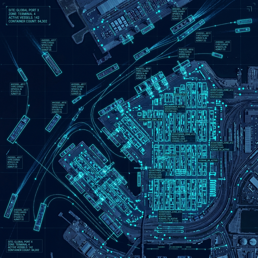
Economic & Activity Detection<br>from Space

Infer behaviour, not just objects

<b style="color: white; font-weight: 600;">Detect cars in parking lots</b> &rarr; measure retail activity

<b style="color: white; font-weight: 600;">Count ships in ports</b> &rarr; track trade flows

<b style="color: white; font-weight: 600;">Read economic patterns from orbit</b>

Geospatial analytics for economic intelligence

SECTION 3 — PLAYER SPOTLIGHTS

CAPABILITY SPOTLIGHT 5 — THE UPGRADE

Multi-Sensor Intelligence

Fusion of different data types

Radio frequency RF signals from space

Combined with optical imagery

Detect what you cannot see, only hear

Multi-layer intelligence fusion

Example

RF signal geolocation plus imagery fusion

SECTION 3 PLAYER SPOTLIGHTS

Shared Architecture Pattern

Every major geospatial intelligence platform does this:

INGEST

Massive data intake

TILE

Break into manageable chunks

EXTRACT

Run feature models

STORE

Fast-access vector storage

QUERY

Real-time retrieval

This is a data engineering problem as much as an AI problem.

SECTION 4 — WHAT THEY HAVE IN COMMON

The Real Innovation

It's not the models.

PRECOMPUTATION

Do the heavy work ahead of time

SMART STORAGE

Structure data for instant retrieval

FAST RETRIEVAL

Sub-second query at global scale

SECTION 4 — WHAT THEY HAVE IN COMMON

Minimal System You Could Build

A modular, composable pipeline — starting today

SECTION 5 — HOW YOU WOULD BUILD THIS

Modular. Composable. Buildable now.

STORE

Cloud-Optimized<br>GeoTIFF (COG) on S3

TILE

Slice into<br>XYZ tiles

EXTRACT

Run model -><br>generate embeddings

INDEX

Store vectors<br>in FAISS

QUERY

Expose via<br>REST API

You don't need satellites<br>to innovate here.

Use open imagery

Build small prototypes

Focus on interaction

The opportunity is in UX + systems, not just data.

SECTION 5 — FINAL THOUGHT

  • geospatial-intelligence
  • satellite-imagery
  • machine-learning
  • sar-radar
  • data-engineering
  • ai
  • remote-sensing